
News
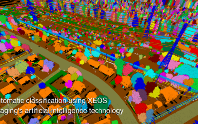
XEOS AI mapping for Power Network Management
Read Geo Week News’ article about our LiDAR and AI-based approach to mapping power lines and vegetation in Eastern Canada. Read the article

XEOS Imaging introduces AI-based mapping of ditches and culverts
The mapping of ditches and culverts is now available on our website.• The area drained by each culvert (in hectares).• The proportion of the drained...

XEOS Imaging launches AI-based mapping of power distribution lines
Behind every power line, there are homes, hospitals, businesses, and entire communities that depend on the reliability of the grid. Thanks to our...

How does our AI prevent power outages caused by hazardous trees?
XEOS Imaging helps electric utilities reduce power outages by using artificial intelligence to identify hazardous trees near power lines and...
XEOS Imaging obtains a European patent in artificial intelligence
XEOS Imaging is proud to announce that the European Patent Office has officially published, on October 15, 2025, a patent for an artificial...

Understanding heat islands
Due to climate change, heat waves are becoming increasingly frequent. This document will help you better understand urban heat islands and reduce...

Understanding blue spots with XEOS Imaging
We often hear about blue spots, without always knowing exactly what they are. Yet mapping them is essential to take action, prevent flooding, and...

XEOS Imaging is a finalist in two categories at the 2025 ADRIQ
We are proud to announce our selection as finalists for the brand-new Fonds de recherche du Québec Award, as well as for the Innovation – Artificial...

A look back at our experience at Viva Tech 2025 in Paris
We have returned from VivaTech in Paris with great pride. The event was a fantastic showcase for highlighting our expertise in artificial...
XEOS Imaging, “Favourite Exhibitor” at the 2025 COMBEQ Conference!
We are proud and grateful to have been chosen as the “Favourite Exhibitor” by attendees of the COMBEQ conference! On April 10 and 11, we had the...